The employees of the Department of Regional Analysis of Adam Mickiewicz University conduct research on the identification of spatial differences in the socio-economic development level and their determinants. As part of the FORSED project “New challenges of regional policy in shaping socio-economic development factors of less developed regions”, funded by the National Science Center (2015/19/B/HS5/00012), we drew attention, among other things, to the significance of historical and socio-political determinants in geography of development differences in Poland. These analyses take a different dimension when we look at the election results at the local level (in the lower right corner a map from Onet.pl showing the PiS victory in constituencies – blue and KO – orange).
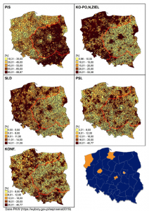
PiS – Law and Justice (Prawo i Sprawiedliwość);
KO – PO, N, ZIEL – Civic Coalition – Civic Platform, Modern, the Greens (Koalicja Obywatelska – Platforma Obywatelska, Nowoczesna, Zieloni);
SLD – Democratic Left Alliance, Spring, Left together (Sojusz Lewicy Demokratycznej, Wiosna, Razem);
PSL – Polish People’s Party, Kukiz’15 (Polskie Stronnictwo Ludowe, Kukiz’15);
KONF. – Confederation Liberty and Independence (Konfederacja).
The pattern in the level of support in the last parliamentary elections (13 October, 2019) clearly relates to the partition boundaries (marked red on the cartograms) and highly correlates with the level of local socio-economic development.
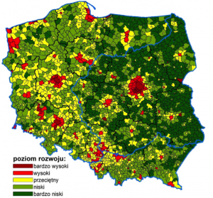
This leads to the conclusion that the spatial pattern of the analysis of socio-economic phenomena is of critical importance for the identified distributions and regularities occurring among them.
The FORSED project team